
Geophysics - Journal of the Society of Exploration Geophysicists and American Association of Petroleum Geologists · 2020
Extracting horizon surfaces from 3D seismic data using deep learning
Why this publication matters
Mapping underground rock layers usually requires experts to trace reflections through enormous three-dimensional scans. This method learns from a limited set of their markings and lets them refine difficult areas interactively. It can reduce repetitive interpretation work while keeping the geologist involved in judging the result.
Abstract
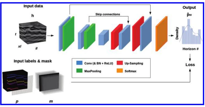
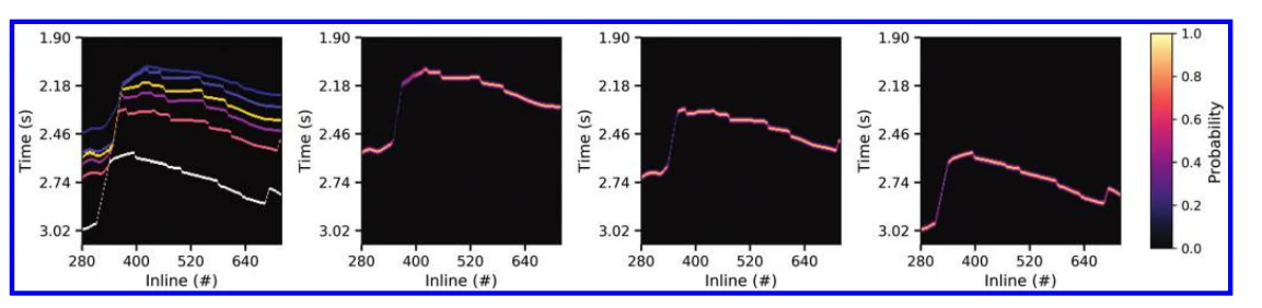
Extracting horizon surfaces from key reflections in a seismic image is an important step of the interpretation process. Interpreting a reflection surface in a geologically complex area is a difficult and time-consuming task, and it requires an understanding of the 3D subsurface geometry. Common methods to help automate the process are based on tracking waveforms in a local window around manual picks. Those approaches often fail when the wavelet character lacks lateral continuity or when reflections are truncated by faults. We have formulated horizon picking as a multiclass segmentation problem and solved it by supervised training of a 3D convolutional neural network. We design an efficient architecture to analyze the data over multiple scales while keeping memory and computational needs to a practical level. To allow for uncertainties in the exact location of the reflections, we use a probabilistic formulation to express the horizons position. By using a masked loss function, we give interpreters flexibility when picking the training data. Our method allows experts to interactively improve the results of the picking by fine training the network in the more complex areas. We also determine how our algorithm can be used to extend horizons to the prestack domain by following reflections across offsets planes, even in the presence of residual moveout. We validate our approach on two field data sets and show that it yields accurate results on nontrivial reflectivity while being trained from a workable amount of manually picked data. Initial training of the network takes approximately 1 h, and the fine training and prediction on a large seismic volume take a minute at most.
Figures
Cite this paper
@article{tschannen2020extractinghorizonsurfaces2,
  title = {{Extracting horizon surfaces from 3D seismic data using deep learning}},
  author = {Valentin Tschannen and Matthias Delescluse and Norman Ettrich and Janis Keuper},
  journal = {Geophysics},
  year = {2020},
  url = {https://library.seg.org/doi/pdf/10.1190/geo2019-0569.1},
  doi = {10.1190/geo2019-0569.1}
}
Figures and abstract are reproduced from the linked research sources. Credit remains with the authors and publishers.